Unveiling Precision and Analysis: An In-depth Exploration of the AREA Command in AutoCAD

The AREA command in AutoCAD is a powerful tool that allows users to calculate the area of closed 2D shapes or regions within their drawings with remarkable precision and efficiency. By providing accurate area measurements, the AREA command enhances accuracy, analysis, and productivity in the drafting process. In this comprehensive guide, we delve into the intricacies of the AREA command in AutoCAD, unraveling its functionality, customization options, and practical applications in various design and drafting scenarios.
Understanding the AREA Command:
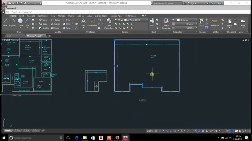
The AREA command in AutoCAD enables users to calculate the area of closed 2D shapes, such as polygons, circles, ellipses, and irregular shapes, within their drawings. This command provides users with a convenient way to determine the total area covered by a particular shape or region, regardless of its complexity or size.
To activate the AREA command in AutoCAD, users can simply type “AREA” in the command line or select the Area tool from the Measure panel of the Home tab. Once activated, users can select the closed shape or region for which they want to calculate the area by clicking within its boundary. AutoCAD then displays the area measurement in the command line, along with the units specified in the drawing settings.
Customization Options:
The AREA command offers a range of customization options that allow users to tailor the area calculation display and behavior to their specific needs and preferences. Some of the key customization options include:
- Measurement Units: Users can specify the units of measurement for the area display, choosing between imperial (square inches, square feet) or metric (square millimeters, square meters) units based on their preference. This ensures that area measurements are displayed in the desired units for clarity and readability.
- Precision: Users can adjust the precision of the area measurement display, specifying the number of decimal places to display in the measurement result. This allows users to control the level of detail and accuracy in the displayed area measurement.
- Coordinate Input: Users can enter coordinates directly into the command line to specify the closed shape or region for which they want to calculate the area, providing a convenient alternative to selecting the shape manually. This allows users to calculate the area of specific regions within the drawing with ease and precision.
- Object Selection: Users can select closed shapes or regions using various object selection methods, such as clicking within the boundary of the shape, selecting multiple shapes at once, or using a window or crossing selection method. This provides users with flexibility and control over the shapes for which they want to calculate the area.
- Custom Units: Users can define custom units of measurement for the area display, allowing them to specify unique unit formats or conversions for specialized drawing requirements. This enables users to display area measurements in custom units that are relevant to their specific industry or project needs.
Practical Applications:
The AREA command has a wide range of practical applications in various design and drafting scenarios. Some common uses of the AREA command include:
- Site Planning: The AREA command is invaluable for site planning tasks, allowing users to calculate the area of land parcels, buildings, or other features within the site plan. This enables users to determine the total land area, building footprint, or site coverage for zoning, development, or regulatory purposes.
- Land Surveying: The AREA command is useful for land surveying applications, allowing users to calculate the area of survey boundaries, property lines, or land parcels within the survey drawing. This provides surveyors with accurate area measurements for property delineation, boundary determination, or land use planning.
- Quantity Takeoff: The AREA command is essential for quantity takeoff tasks, allowing users to calculate the area of construction elements, such as walls, floors, or roofs, within the building design. This enables estimators, contractors, or project managers to accurately quantify material quantities, labor requirements, or cost estimates for construction projects.
- Civil Engineering: The AREA command is indispensable for civil engineering projects, allowing users to calculate the area of roadways, parking lots, or drainage basins within the civil engineering design. This provides engineers with critical area measurements for grading, drainage, or site development calculations.
- Environmental Analysis: The AREA command is valuable for environmental analysis tasks, allowing users to calculate the area of natural features, such as wetlands, forests, or watersheds, within the environmental assessment drawing. This enables environmental scientists, planners, or regulators to assess habitat size, biodiversity, or ecological impact for environmental planning or conservation efforts.
Conclusion:
The AREA command in AutoCAD is a versatile and indispensable tool that empowers users to calculate area measurements with precision and efficiency, enhancing accuracy, analysis, and productivity in the drafting process. By providing users with a comprehensive set of customization options and practical applications, the AREA command enables users to navigate complex design challenges with ease and confidence. Whether used for site planning, land surveying, quantity takeoff, civil engineering, or environmental analysis tasks, the AREA command remains a cornerstone of modern design workflows, enabling users to master precision and efficiency in their drawings.


