Mastering Urban Space Design and Public Park Planning in InfraWorks: A Comprehensive Guide
Introduction: Urban spaces and public parks play a vital role in shaping the quality of life in cities, offering opportunities for recreation, social interaction, and connection with nature. Designing these spaces requires careful consideration of various factors, including functionality, aesthetics, sustainability, and community needs. Autodesk InfraWorks provides powerful tools and capabilities for urban space design and public park planning, enabling designers, planners, and stakeholders to visualize, analyze, and optimize these spaces in a 3D environment. This comprehensive guide aims to provide a detailed overview of how to design urban spaces and public parks in InfraWorks, offering step-by-step insights and expert tips to master this essential aspect of urban planning and design.
Understanding Urban Space Design and Public Park Planning: Urban space design involves the planning and design of outdoor spaces within urban areas, including streetscapes, plazas, squares, and pedestrian areas. Public park planning focuses specifically on the design and development of parks and green spaces, providing opportunities for recreation, relaxation, and community engagement. Both disciplines require consideration of factors such as site analysis, spatial organization, circulation, landscaping, amenities, and user experience to create vibrant, inclusive, and sustainable urban environments.
Key Features of InfraWorks for Urban Space Design and Public Park Planning: InfraWorks offers a range of features and tools tailored for urban space design and public park planning, including:
- 3D Modeling: InfraWorks provides intuitive tools for creating detailed 3D models of urban spaces and public parks, enabling designers to visualize their ideas in a realistic environment.
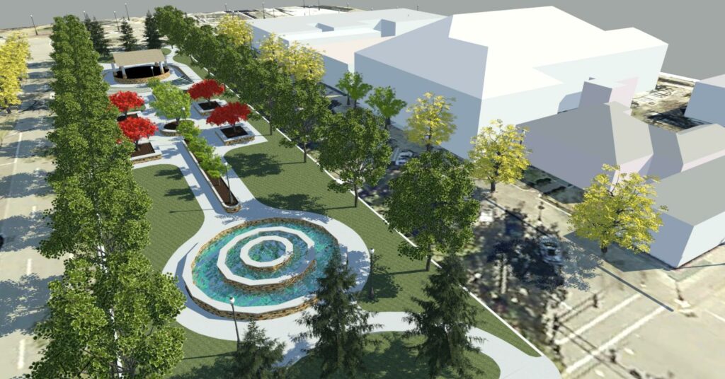
- Visualization: The software offers realistic rendering capabilities that allow users to visualize urban spaces and public parks in high fidelity, including materials, textures, lighting, and landscaping.
- Analysis: InfraWorks includes analysis tools for assessing various aspects of urban spaces and public parks, such as pedestrian flow, solar exposure, accessibility, and environmental impact.
- Collaboration: InfraWorks facilitates collaboration among multidisciplinary teams by enabling cloud-based sharing of models and real-time project updates, ensuring seamless communication and coordination throughout the design process.
Designing Urban Spaces and Public Parks in InfraWorks: The process of designing urban spaces and public parks in InfraWorks involves several key steps, from site analysis to conceptual design and visualization. Here’s a comprehensive guide to designing urban spaces and public parks in InfraWorks:
- Conduct Site Analysis:
- Begin by conducting a comprehensive analysis of the site, including its location, context, topography, land use, existing infrastructure, and environmental conditions.
- Gather data from various sources, such as maps, surveys, aerial imagery, and GIS data, to inform the design process and identify opportunities and constraints.
- Define Design Objectives and Program:
- Define the design objectives and program for the urban space or public park, considering factors such as user needs, community preferences, and project goals.
- Establish clear design goals and priorities, such as providing recreational amenities, enhancing biodiversity, promoting sustainability, and fostering social interaction.
- Generate Conceptual Designs:
- Generate multiple conceptual designs for the urban space or public park, exploring different layout options, spatial arrangements, and design themes.
- Use InfraWorks’ 3D modeling tools to create conceptual models of the designs, experimenting with different forms, textures, colors, and materials to convey design intent.
- Evaluate Design Alternatives:
- Evaluate the strengths and weaknesses of each design alternative, considering factors such as functionality, aesthetics, sustainability, cost, and feasibility.
- Use analysis tools in InfraWorks to assess the performance of each design alternative, such as pedestrian circulation, solar exposure, wind flow, and visual impact.
- Refine and Optimize Design:
- Refine the selected design alternative based on feedback from stakeholders, community input, and analysis results.
- Optimize the design for efficiency, functionality, and user experience, making adjustments as needed to enhance spatial organization, circulation patterns, and amenities.
- Visualize and Communicate Design:
- Use InfraWorks’ visualization tools to create compelling visualizations of the final design, including renderings, animations, and interactive presentations.
- Communicate the design to stakeholders, decision-makers, and the public through presentations, workshops, and digital media, soliciting feedback and fostering buy-in.
Best Practices for Urban Space Design and Public Park Planning in InfraWorks: In addition to following the step-by-step guidelines outlined above, here are some best practices to optimize urban space design and public park planning in InfraWorks:
- Engage Stakeholders: Engage with stakeholders, including local authorities, community groups, and residents, throughout the design process to gather input, solicit feedback, and ensure alignment with community needs and aspirations.
- Design for Diversity: Design urban spaces and public parks to accommodate a diverse range of users, activities, and preferences, ensuring inclusivity and accessibility for people of all ages, abilities, and backgrounds.
- Prioritize Sustainability: Prioritize sustainability in urban space design and public park planning by integrating green infrastructure, sustainable materials, energy-efficient lighting, and water conservation measures into the design.
- Embrace Innovation: Embrace innovative design solutions and technologies, such as smart infrastructure, sensor networks, and interactive installations, to enhance the functionality, resilience, and user experience of urban spaces and public parks.
- Plan for Flexibility: Design urban spaces and public parks with flexibility in mind, allowing for adaptation and evolution over time to accommodate changing needs, trends, and demographics.
Conclusion: Designing vibrant, inclusive, and sustainable urban spaces and public parks is essential for creating livable, resilient, and thriving cities. By following the comprehensive guide and best practices outlined above, designers, planners, and stakeholders can master the process of designing urban spaces and public parks in InfraWorks, leveraging its powerful tools and capabilities to create compelling designs that enhance the quality of life for residents and visitors alike. With its intuitive interface, realistic visualization, and advanced analysis tools, InfraWorks empowers users to explore creative solutions, optimize design outcomes, and contribute to the creation of vibrant and sustainable urban environments that enrich communities and inspire future generations.