Bridging Reality and Virtuality: A Comprehensive Guide to Placing Your Model in a Real-World Location in AutoCAD
Introduction:
In the ever-evolving landscape of Computer-Aided Design (CAD), the capability to integrate virtual models with real-world locations is a transformative feature. AutoCAD, a pioneering CAD software, provides tools that enable designers to place their models within the context of actual geographical environments. This extensive guide aims to delve into the intricacies of placing your model in a real-world location in AutoCAD, exploring the functionalities, applications, and the profound impact this feature has on merging the virtual and physical realms.
Section 1: The Significance of Real-World Location Integration
1.1 Contextual Design: The integration of real-world locations in AutoCAD allows designers to contextualize their models within the physical environment. This adds a layer of realism, facilitating better decision-making, spatial understanding, and communication of design intent to stakeholders.
1.2 Urban Planning and Architecture: Delve into the applications of real-world location integration in urban planning and architecture. Explore how placing models in actual locations aids in assessing the impact of designs on surroundings, optimizing spatial relationships, and enhancing the overall sustainability of projects.
Section 2: Geographic Information System (GIS) Integration in AutoCAD
2.1 Introduction to GIS Data: Understand the role of Geographic Information System (GIS) data in real-world location integration. Explore how GIS data, comprising geographical features, terrain information, and satellite imagery, serves as the foundation for accurately placing models within specific locations.
2.2 Importing GIS Data into AutoCAD: Learn how to import GIS data into AutoCAD. Understand the process of accessing and incorporating geographical information, such as terrain elevations, property boundaries, and road networks, into your AutoCAD drawings.
Section 3: Configuring Geographic Location Settings in AutoCAD
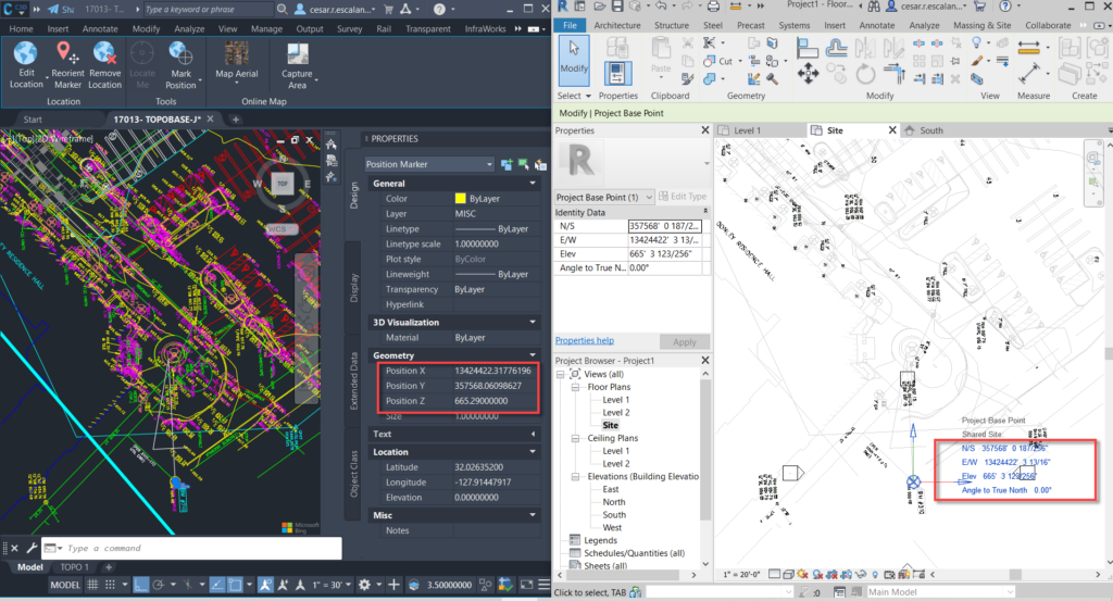
3.1 Setting Geographic Location: Explore the Geographic Location feature in AutoCAD. Learn how to set the geographical location of your project, specifying coordinates, defining the north direction, and establishing the real-world context for your model.
3.2 Online Map Services: Delve into the utilization of online map services in AutoCAD. Understand how to leverage services like Bing Maps or Google Maps to enhance the accuracy and visual representation of your model within a real-world location.
Section 4: Locating Your Model with Latitude and Longitude
4.1 Coordinates and Geographic Placement: Understand the significance of latitude and longitude in geographic placement. Learn how to use these coordinates to precisely position your model within a real-world location, ensuring accurate alignment with the surrounding environment.
4.2 Coordinate Systems and Transformation: Explore coordinate systems and transformation methods in AutoCAD. Understand how to convert between different coordinate systems, ensuring compatibility with GIS data and achieving seamless integration with real-world locations.
Section 5: Terrain Modeling and Contour Integration
5.1 Terrain Modeling Overview: Delve into terrain modeling in AutoCAD. Learn how to incorporate elevation data from GIS sources to create accurate representations of the topography, allowing for realistic placement of your model within varied landscapes.
5.2 Contour Lines and Surface Representation: Explore the use of contour lines in AutoCAD. Understand how contour lines derived from GIS data contribute to surface representation, aiding in visualizing the terrain and ensuring your model harmonizes with the natural landscape.
Section 6: Enhancing Realism with Aerial Imagery
6.1 Aerial Imagery Integration: Explore the integration of aerial imagery in AutoCAD. Learn how to incorporate high-resolution satellite or aerial photographs into your drawings, enhancing the realism and providing a visual reference for the real-world context of your model.
6.2 Adjusting Image Transparency: Understand how to adjust image transparency in AutoCAD. Explore techniques for blending aerial imagery with your model, ensuring a seamless integration that captures the nuances of the actual surroundings.
Section 7: Dynamic Updating and Collaboration
7.1 Real-Time Updates: Delve into real-time updates in AutoCAD. Learn how changes in the real-world environment can be reflected in your model through dynamic updating, ensuring that your designs remain aligned with the evolving context.
7.2 Collaborative Workflows: Explore collaborative workflows with real-world location integration. Understand how multiple team members can work on different aspects of a project, incorporating designs within a shared real-world context and maintaining consistency across collaborative efforts.
Section 8: Sun and Shadow Studies for Real-World Lighting
8.1 Sun Studies in Geographic Context: Understand the importance of sun studies within the context of real-world locations. Learn how to simulate the movement of the sun over a specific geographical area, enabling designers to analyze shadows, sunlight exposure, and the visual impact of their models.
8.2 Daylighting Analysis: Explore daylighting analysis in AutoCAD. Understand how real-world lighting conditions can be assessed within the software, allowing designers to optimize building orientations, assess solar exposure, and enhance the sustainability of architectural designs.
Section 9: Exporting Models with Real-World Coordinates
9.1 Exporting Georeferenced Models: Learn how to export georeferenced models from AutoCAD. Explore the process of creating GeoTIFF files or exporting to Geographic Information System (GIS) formats, ensuring that your models can be seamlessly integrated with other GIS software or shared with collaborators.
9.2 Web-Based Visualization Platforms: Delve into the utilization of web-based visualization platforms. Understand how exporting georeferenced models allows for interactive online visualization, providing stakeholders with an immersive experience of your designs within their real-world context.
Section 10: Challenges and Troubleshooting
10.1 Common Issues with Real-World Location Integration: Address common challenges encountered when integrating real-world locations in AutoCAD. From discrepancies in GIS data to issues with coordinate transformations, gain insights into effective problem-solving strategies to ensure accurate placement of your model.
10.2 Troubleshooting Tips: Explore troubleshooting tips for resolving issues related to real-world location integration. From optimizing performance to addressing conflicts with other design elements, understand how to maintain precision and reliability in your geospatially referenced models.
Section 11: Future Trends and Emerging Technologies
11.1 Augmented Reality (AR) Integration: Delve into the potential integration of Augmented Reality (AR) with real-world location placement in AutoCAD. Explore how AR technologies may provide designers with on-site visualization capabilities, enhancing the immediacy and accuracy of design decisions.
11.2 Environmental Simulation and Analysis: Explore emerging technologies that enable advanced environmental simulation and analysis in AutoCAD. Understand how these tools may provide designers with comprehensive insights into the impact of designs on the natural environment, shaping the future of sustainable design practices.
Conclusion:
As we conclude this exhaustive exploration of placing your model in a real-world location in AutoCAD, it is evident that this feature is a game-changer in the CAD environment. Whether you are an architect seeking to integrate your designs seamlessly into urban contexts or an urban planner assessing the impact of developments on the existing landscape, the ability to place models within real-world locations provides invaluable insights. Embrace the context, accuracy, and visual richness that real-world location integration brings to your AutoCAD workflow, and witness how this transformative tool elevates your designs from isolated virtual entities to contextualized and impactful representations. With continuous practice, exploration, and innovation, you will navigate the intricate landscape of real-world location integration with confidence, producing designs that seamlessly merge the virtual and physical realms in the dynamic world of CAD.